Neil Armstrong's reentry skip
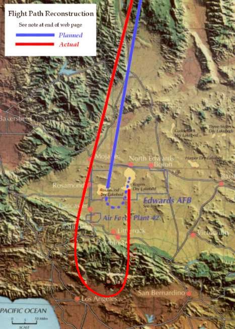
A note on flight path reconstruction...
The actual flight path mapped in red on
this web page is reconstructed from information in the map of the
planned
flight path, the pilot's postflight notes, the radio communications
transcript,
and additional recent comments offered by the pilot, Neil Armstrong
This author derived the shape of the turn
over the San Gabriel
Mountains and the northern part of the Los Angeles Basin by graphically
rotating and reflecting the ground track from the only surviving radar
plot of an X-15 mission. That mission was Bob White's FAI altitude
record flight, which also finished with an overshoot of the landing
site. White passed Edwards AFB at about 60,000 feet and Mach 3,
Armstrong passed at just over 100,000 feet and Mach 3. Both used
similar control inputs and aircraft attitudes to produce a 3g turn for
the return to Rogers Dry Lake. In both cases this was a windup turn,
with radius decreasing as the X-15 descended and slowed.
Accuracy of this reconstructed plot of the
flight path cannot be
confirmed in the absence of actual radar data, and even the pilot is
unable to provide precise visual information because downward
visibility from
the X-15 cockpit is quite limited. However, the combination of details
in the flight log and constraints inherent in the physics of flight
provide high confidence that the derived plot has fairly good accuracy.
Thanks for information used to produce
this flight path reproduction
go to Neil Armstrong, Major General Robert M. White, Ret., and the NASA
Dryden History Office.
Send comments or questions by email to Paul Raveling